


Battle of Bradfield (BOB)
18/03/2018 - Sheffield - Sportive
Rating: 
Previous Years Rating: 97.8% based on 2 reviews
The Battle of Bradfield Sportive Preview
Stannington, Sheffield |
Kick start your road biking/sportive season with Dark & White Cycling's new short but tough sportive the Battle of Bradfield (B.O.B) taking place on 19th of March from Stannington, Sheffield.
This challenging cycling event on the North Eastern fringes of the Peak National Park proves that in order for a sportive to be tough it does not need to take all day. The Yorkshire cousin to Derbyshire's Matlock Top 10 the B.O.B sticks to the same successful format of ten hard climbs many with 20% + gradients over a 63 km/38 mile route. For those that don't want to tackle the full 10 climbs but still want to experience the B.O.B there will be a shortened 33km/20mile route that covers just 4 of the ten climbs.
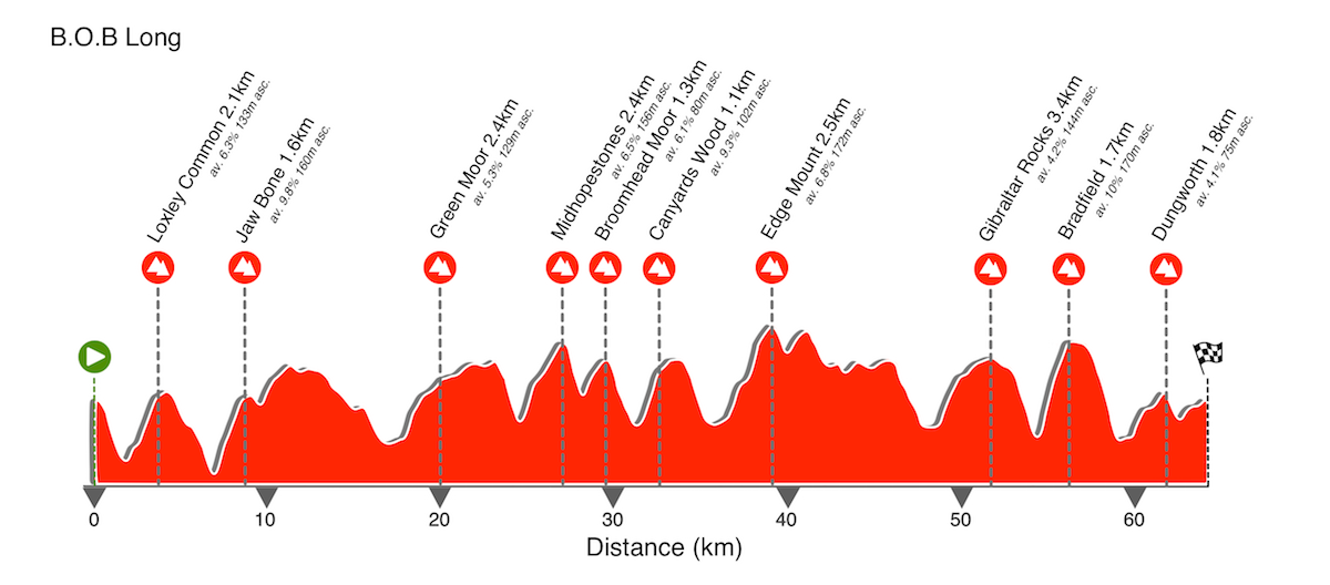
The Battle of Bradfield sportive promises plenty of ultra smooth roads as used on Stage 2 of the 2014 Tour de France. Starting from Stannington to the west of Sheffield the anti-clockwise route initially heads north passing through Worrall, Oughtibridge and Greno Woods. It then heads off west climbing up in the direction of Penistone before turning south and picking up the Tour de France route and the 2.4km/1.5mile climb of Midhopestones. From the south side of the Broomhead Reservoir riders will be faced with the challenging steep 1.1km/0.7 miles 25%+ ascent of Canyard's Hill. A loop around Spout House Hill brings the riders up to Edge Mount and it's then on to Agden Bridge and Dale Dike reservoir with a climb up to Gibraltar Rocks before swooping down to Lower Bradfield to begin the testing 20%+ climb out of Bradfield - this will be twice as long as the ascent used on The Tour as riders must first battle their way up to Upper Bradfield. With Bradfield done and dusted all that stands in the way of the riders and some well earned tea and cake is the final climb of Dungworth.
The whole route will be fully signed with a marshalled checkpoint/feed station approximately halfway around. In addition to the regular signage there will be bespoke en-route climb boards at the roadside like you find in the Alps and Pyrenees depicting average gradient, metres of ascent and length of all the 10 major climbs.
On the day expect:
- A clearly signed/arrowed route
- Feed-station providing a selection of the best OTE sports nutrition along with usual juice, biscuits and bananas
- En-route climb information boards
- Colour route map including emergency numbers
- SPORTident chip timing for an instant post-event time
- Refreshments at the finish
- Event Photographer Chris Meads
- Finishing certificates: Gold, silver and bronze awards based on your finishing time. Separate women award times.
Visit the website for more information incl. route maps, climb profiles
|
|
|||||||||||||||||||||||||||||||||||||||||

You May Also Like...


Events You May Also Like...
 Cycling Down Dementia Norfolk 2020
Weeks to go until event: less than 6 weeks
Cycling Down Dementia Norfolk 2020
Weeks to go until event: less than 6 weeks
